Eastern Aero Carto Pvt. Ltd (EACPL formerly known as EACC – EASTERN AERO CARTO AND CO) was founded by Roy George Mantosh who is of Indian and Swiss descent in the year 1997. EACPL is engaged in the production of 3D/2D/LiDAR and most recently the sale of high resolution satellite imagery from our principles “M/s. SkyCues Geneva,Switzerland”. As EACPL has complete clearance from the ministry of defence government of India to carry out aerial photography, therefore we have acquired our own aircraft. Details provided below :-
We are engaged in different types of Geo spatial Projects for National & International Clients.
We have been empanelled by different prestigious Indian Government organization for the task of GPS survey and GIS solution in the field of Power, municipal/town planning, water, telecommunication, vehicle navigation, irrigation etc. throughout India. We have been honoured by the “No Objection Certificate” by the Ministry of Defence for carrying out aerial photography. We are the first Indian Company in the private sector to hold this prestigious certification.
EACPL is now in full technical and GIS production with M/s. Huber Kartographie GmbH, Munich, Germany from the year 2011, and have carried out hundreds of projects for the company. We have also been short-listed with Huber Kartographie by ANDHRA PRADESH MUNICIPAL CORPORATION for carrying out survey/GIS projects for them, please visit www.kartographie.de for further information. As of date, we have completed over 10 Millions Ha.of various 3D mapping projects for M/s. ESTEREOFOTO GEOENGENHARIA, Lisbon, Portugal.
Our continuous endeavour is to implement and maintain ISO 9001-2000 norms, While ISO Certification is already under way. Quality is our priority and our commitment to quality is our key to success.
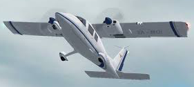
Regards to our aircraft, we have at our disposal a Partenavia. P68C, with camera hatch, the same is maintained in Bangalore by M/S.GLOBAL CONNECTAIR.
